The weekend of September 10th we boarded our trusty Tahoe, and headed out for what we hoped would be a good look at the changing aspens. As it turns out, we were about a week and a half early, but we still had one of our best scenic drives through an area of Colorado we had not known about. Apparently few others knew about it as well.
We started out heading South on I-25, took the highway 115 bypass to U.S. Route 50, and headed West through Canon City, Salida, and onto Gunnison. US 50 is a reasonably scenic highway, with parts of it winding along the Arkansas river, in canyons I presume were carved by the same.

Past Salida, heading up to Monarch Pass, we pass a working mine. Probably a common sight to many in the area, but new enough to me to be worth a couple of photos.
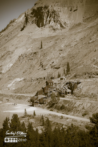
Yes, I gave it the old photo treatment. Somehow it seemed appropriate.
The drive is quite pleasant, the weather is nice, and the snacks are very good.
By late afternoon we are in Gunnison, and dine at a very nice restaurant called the Gunny Sack. The Fish and Chips are excellent, and the special for the week, large salmon cakes, are also good. The leftovers will serve as snacks the next day, during the drive down Highway 149 to South Fork.
Highway 149 heads South just west of Gunnison, crossing the Blue Mesa Reservoir, following it for a bit, and then heads up into the surrounding hills.
The road is in very good shape, and travel the next morning is easy and relaxing, especially since for the first hour or so we don’t see any other cars. Rounded hills give way to more rugged features, and the changing scenery rolls by effortlessly.


The drive to Lake City does not offer much in way of aspen groves, although many of the surrounding distant hills have the familiar soft green intermixed with the darker evergreen trees.
As we get Close to Lake City more aspens groves are showing up, but they have yet to turn.
Instead we admire the deep cut the Gunnison river has carved into the earth. We follow the river all the way into Lake City, although, save for the glimpses when the road ventures close to the steep drop-off, the river itself is hidden from view.
Lake City itself is fairly unassuming, and while we probably should spend some time absorbing the local history, we still have many miles to go before we sleep. Besides, there are people milling about, and these days people are not impressing me much as beings I want to be around. We breeze through Lake City, and start heading up toward Slumgullion Pass.
As climb, we pass the site of the Lake City Massacre, where Alfred Packer decided to have himself a taste of his traveling companions when the group became lost in a snowstorm. One of the best quotes I ever read is attributed to the local saloon keeper regarding the event.
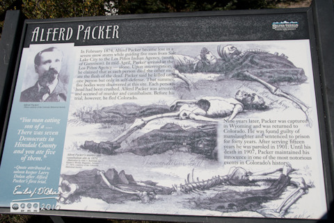
“You man eating son of a . . . There was seven Democrats in Hinsdale County, and you ate five of them.” You can’t make this stuff up. I considered having my picture taken next to the sign while munching on a sandwich, but I reconsidered, thinking it may be a tad disrespectful to the dinners . . . er . . . men who lost their lives there.
Still climbing, we pass a few overlooks, one of which gives us a good view of Lake San Cristobal.
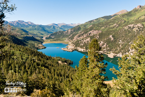
For some reason, WordPress does not always insert pictures that are the same quality as what I output. If you don’t look at any other pictures, the few of the lake are the ones that might be worth your time. The vista is grand, and it reminds me of some of the mountain lakes we saw in Europe. Click on the above picture to be taken to the album (or wait until you read everything, and then go look at the pictures).
Alas, one can see the aspens are still green, and this is where we decide to return on the following week.
A little farther up we take the short drive that takes us to the Windy Point Overlook.

If you click on the picture you will be taken to the SmugMug gallery, and you can opt to see this picture in the original size. (Note: it’s a big file. Depending on your connection, it may be a few minutes to show up on Original. Also, if you are running FireFox, it may hang up if asking to see the original size. IE or Chrome seem to work much better when looking at original sizes.)
This is the site where gravity, aspens, a loose boulder, and excessive hubris all conspired to make me look less than the svelte, agile, balance machine I am.
You see, aspens had grown to block most of the view, so people were standing on the benches to take pictures. One person climbed atop his SUV. Being people, I too had stood atop a bench, and it seemed convenient to get down by walking on the progressively smaller boulders leading back to my car (they were there to mark the boundary of the parking area). There I was, agility in motion, carrying my camera with the big lens on one hand, and the wide angle lens in the other hand, casually striding from boulder to boulder. I reach my destination, step on the last boulder, shift my weight for the final dismount . . . and the boulder moved out from under me. You see, not all of it was touching the ground.
The area hidden from me was angled, leaving 6-8 inches open under the far edge. Unfortunately, when it moved I had already shifted my weight, and my center of gravity ended up far outside the one leg still in contact with the now terra mobile. I was going down, and I realized I was holding a sizable investment in lenses and camera (insured to be sure, but . . . ).
I had no way to break my fall, or recover my balance. Flesh met ground, but I managed to keep the lenses and camera from hitting anything. Unfortunately, in the process I got some scrapes, and embed small stones on various parts of my exposed flesh.
No major damage other than to my ego and exposed skin. My ego would keep on suffering for an number of days as my loving wife diligently recounted the story to all who would listen.
We pressed on.
A little farther down we came to the headwaters of the Rio Grande.
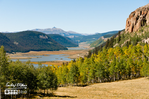
The small picture above does not do the views justice. Click on the photo to see them properly.
While there we realized we missed the Clear Creek Falls. Understand, there are hills here, but most of the land is fairly flat. I had little illusion it would be worth it, but we decided to go back a few miles and go see what are supposed to be very nice falls.
The small parking lot is only a quarter mile from the highway (4 miles if coming the other way), and as we parked we could not see anything resembling falls. However . . .
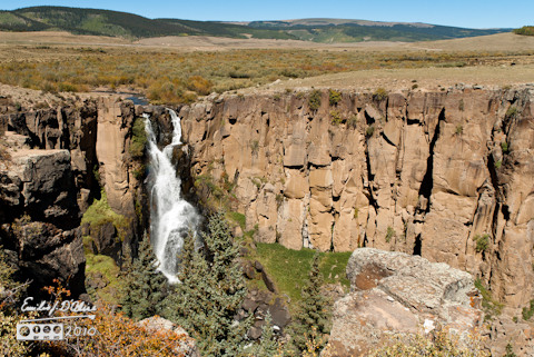
walk 50 yards or so, and you hear the unmistakable sound of falling water, and you begin to see the top of a large chasm in the ground. Honest to goodness, the sight takes your breath away. It’s so unexpected, so seemingly out of place, that you have a hard time reconciling what you see with where you are.
The volume of water going over the edge is impressive, especially given the small stream that feeds it, and how late in the year it is. I imagine after the snow melt this thing would be even more amazing. Anyway, pictures were snapped a-plenty. If interested, click on the above picture.
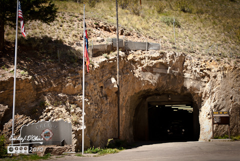
After this we continued to Creede, a small town nestled in a box canyon, and famous for its saloons lining main street. Saloons that attracted the likes of Calamity Jane and Bat Masterson. All I saw were tourist shops, but I’m sure there were some saloon there.
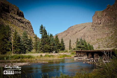
I did not take many picture, figuring I would return and spend some time here. For now we just used it as a rest stop, and moved on. We continued following the Rio Grande to South Fork, where we picked up Highway 160, and started on our way home. Sure, there were some good sights, but few more pictures were taken, as with rare exception they were repeats of prior stuff.
One of the things we saw when in Lake City were signs to something called the Alpine Loop. That, my readers, will feature prominently on Part Two of the report of the two weekends we spent color-touring the Southwest portion of Colorado.
Meanwhile, the Silver Thread Byway is a road we will look forward to traveling in years to come, and to be happy doing it.
To my chagrin, I lived in Colorado for 5 years and neglected to visit this section of the state. Thanks for illustrating it with your pixels and prose.
LikeLike
Great pictures and a terrific “tour guide” view of the route. I’m thinking that might be a nice trip for my wife and me to take next spring or summer. We’ve been to that corner of the state a couple of times, but this would be a nice exploration of a new part for us. I would especially look forward to Lake San Cristobal, Clear Creek Falls, and the Rio Grande headwaters area.
LikeLike
Your photos are beautiful! I’ve never been to this area-thanks for sharing!
LikeLike
Wonderful story and adventure! We (sadly) don’t spend much time in Lake City when we pass through on these trips, because there are RARELY any restaurants open. You can almost always find an open bar or two in any of these little Colorado towns, but finding something to eat… better pack an ice chest. 😉
LikeLike
Yeah . . . we travel with enough provisions to feed a small town.
LikeLike
Thanks for posting this. Beautiful stuff, and helpful for others.
LikeLike
You are welcome . . . I hope you went to the SmugMug gallery. It has about 60 photos.
You might also be interested in these two posts:
https://disperser.wordpress.com/2010/10/24/lake-city-colorado-and-the-alpine-loop-part-i/
https://disperser.wordpress.com/2010/11/05/lake-city-colorado-and-the-alpine-loop-part-ii/
Be forewarned if you are thinking of going on the alpine loop.
LikeLike
Yup, this is a beautifully presented post . . . between the great narrative and excellent photos, it flows grandiosely . . . in honor of the Rio Grande!
LikeLiked by 1 person